


Recent
Most read


The use of 3D and interactive digital maps, instead of paper maps and atlases, has been ushered in by the coronavirus pandemic and will continueÌýto grow in the new school year.
New online teaching methods used throughout lockdowns have meant software such as Teams, SwayÌýor OneNote were more heavily relied upon. In geographyÌýwe can, for example, useÌýfreeÌýsoftware from Esri UK’s ÌýtoÌýeasily embed digital maps into these online platforms, as well as use them in the classroom. This allows pupils to access up-to-date interactive maps and the accompanying spatial data.
The digital approach makes lessons more interactive and fun, and is a great example of how edtech helps to accelerate learning. When you give pupils a digital map, there is generally more information available owing to the various layers that can be added, allowing them to investigate and zoom in onÌýparts of the data thatÌýinterest them most - it really is personalisation and choice in action.
Covid: The edtech project that trained 10,000 teachers
Quick read:ÌýHow we can decolonise geography in schools
°Â´¡°Õ°ä±á:ÌýHow a drone is helping children make the transitionÌýto ‘big school’
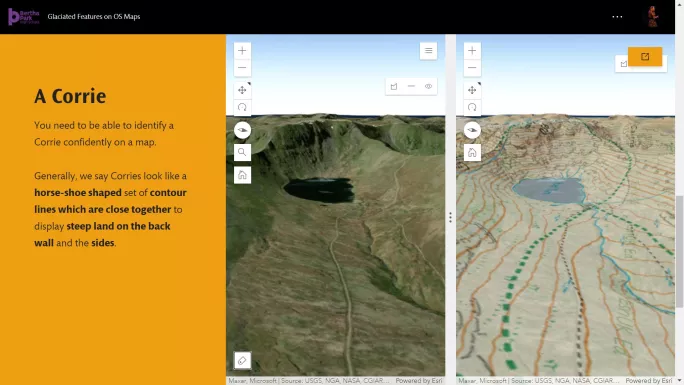
An example of this is how pupils previously used only paper to draw cross-sections of contours to see the landscape in 3D. But now we can quickly embed a digital 3D map and overlay contours. It would have taken far longer for the whole class to arrive at the same pointÌýbut being able to show them in 3D made the lesson more engaging and memorable. The 100 per centÌýdigital resource can also be reused for revision, accessed via a pupil’s OneNote and used with other classes in the future.
Ìý
The geography department also used gamification techniques to create an online for more thanÌý120 children who joined the school last year. This introduced the children to their new classmates and teachers, as physical school visits weren’t possible. The tool was reused in the latest transition,Ìýalong with class-based activity, and it will continue to enhance the transition for P7s next year.
Future plans for edtech include using data collecting apps on mobile phones to gather spatial data,Ìýso that pupils in geographyÌýcan make their own maps andÌýlead their own investigative learning.
Jacquie Black is a geography teacher at Bertha Park High School in Perth. She tweets at @MissBlackGeo